Long Cemetery

Dodge County, Georgia

Find a Grave Cem ID: N/A

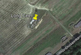
Directions to Cemetery Overview of Cemetery          |GPS Coordinates:  (32.372741, -83.259136)
From Red Light in Eastman intersection of Hwy 117, 87, 46, 341 Bus & 23

Turn northeast on 5th Ave toward Eastman St, go 0.2 mi

Turn left onto Anson Ave, go 0.2 mi

Turn left onto Page St, go 1.4 mi,

Continue onto Chester Hwy, go 7.5 mi

Turn left onto Roddy Hwy, go 7.5 mi

Turn right onto W Chicken Rd, Go 0.5 mi

Cemetery is on left down lane.
 

List of tombstones in Cemetery

Comments from Sources:

2002 team did not identify any unmarked graves.

Picture of Cemetery  


Burial by Years Statistics Burial by Age Statistics Surname Statistics
<1880's:
1950's:
1880's:
1960's:
1890's:
1970's:
1900's:
1980's:
1910's:
1990's:
1920's:
2000's:
1930's:
2010's:
1940's:
2020's:
Unknown:
Unmarked:
Total Bur:
Unk Infants:
50's:
Infants:
60's:
10's:
70's:
20's:
80's:
30's:
>80's:
40's:
Unknown:
Total Different Surnames:
First buried Surname: in

Email Webmaster

Last Update:  23 Jan 2024

Note:  Every effort was made to find each cemetery and list all known people buried in the cemetery through electronic search.  However, the list is not kept up daily and data after 2017 may or may not be listed.  An indication of an unmarked Grave came from the absence of the listing in the 2003 cemetery book.  Obviously, the grave could have been missed by the taker or by myself as I entered the data.  The People's Legacy website could have placed the grave in the wrong cemetery.  But the most probable reason was that the grave was not marked. Find a Grave does not always have a picture of the tombstone nor the right cemetery named. Tombstone name with 2(**) after it indicates that the name has not been confirmed by either printing in a book or by actual on-site investigation.  For those names the following concepts area followed, Male:  first name, middle initial and last name plus Jr/Sr/etc, Females:  first name, maiden name initial and married surname.